
When the map no longer matches the land: New research sheds light on urbanisation in the former homelands
On Friday 15 May, a Policy Dialogue on Urbanisation Processes in the Former Homelands of Mpumalanga Province brought together government officials, academics, and civil society representatives at the Tfokomala Hotel and Conference Centre on the University of Mpumalanga’s Mbombela Campus. The dialogue centred on a substantial draft research report prepared by a team of over twenty scholars from South African and international universities, as part of a British Academy-funded project examining how evidence shapes policy-making in the former bantustans of post-apartheid South Africa.
The findings are important, and for those of us who live and work in the Kruger to Canyons Biosphere Reserve, they are also deeply familiar.
A Landscape Misread
The central argument of the report is deceptively simple: South Africa’s former homelands have long been mischaracterised as rural and agricultural, when in reality they have been functionally urban and integrated into regional and metropolitan economies. For decades, Mpumalanga’s own Development Perspective noted that the province was 73% functionally urbanised, even when the formal urbanisation rate was recorded at just 27%. That critical insight, the report notes, was largely forgotten in the policy processes that followed.
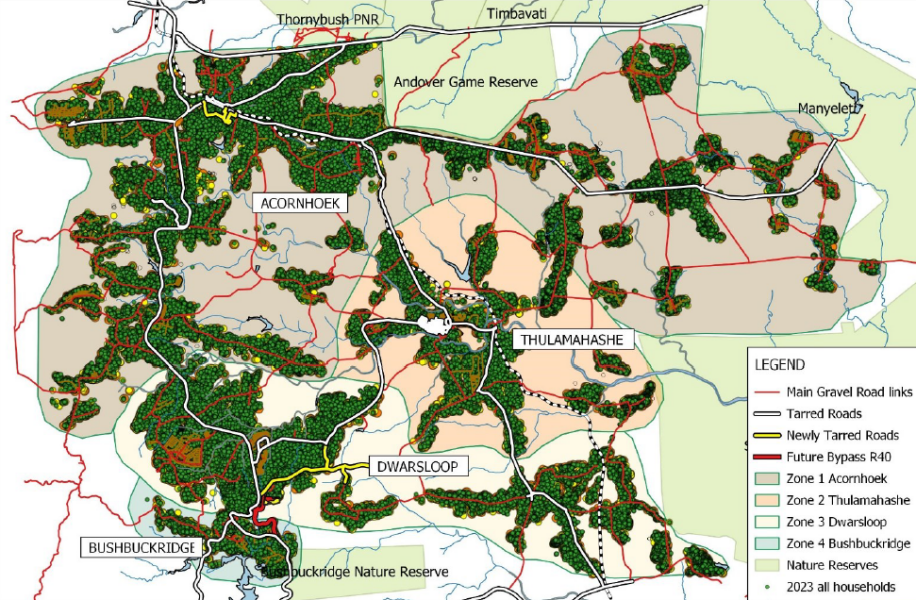
This matters enormously for the Bushbuckridge Local Municipality, which falls within the K2C Biosphere Reserve. The research documents a remarkable demographic turnaround: after population decline in the early post-apartheid years and only modest recovery through 2011, the Bushbuckridge area saw a combined population increase of over 228,000 people between 2011 and 2022 — one of the fastest growth rates in the country. Building data from satellite imagery confirms what Census figures suggest: between 2010 and 2020, residential construction expanded rapidly across virtually all settlements in the municipality.
Growth from the Inside Out
What is driving this growth? The report points to a complex intersection of factors: the relatively low cost of accessing land under neo-customary tenure through traditional authorities; strong emotional, cultural, and familial ties to places like Bushbuckridge — what researcher Leslie Bank has called “heartland urbanism”; the increased circulation of household income through post-apartheid social grants; and a vibrant regional economy anchored in wildlife tourism, commercial agriculture, and mining.
For those working in nature conservation and sustainable livelihoods, one finding deserves particular attention. Women, the report shows, are the primary drivers of the construction economy in Bushbuckridge, financing home-building through grants, wages, and stokvels. But the cost pressures of self-build construction have led many households to rely on locally produced bricks made from illegally mined river sand, with plaster sand similarly sourced from riverbeds. The environmental consequences are significant and directly threaten the water resources that communities, ecosystems, and the broader regional economy depend upon.
Shopping malls have followed the population growth. Eight have been developed in Bushbuckridge between 2018 and 2022 alone, with anchor tenants such as Shoprite and Cashbuild and the grant economy flows largely through these spaces. Yet the report notes that the government, as the provider of those grants, is largely invisible in the interactions that happen there. The result is a consumer economy that is visible and growing, sitting alongside deepening infrastructure deficits and a municipality whose rates base covers barely 10% of its land area.
A Governance Frontier
The Bushbuckridge Local Municipality’s response to all of this has been to develop the concept of a “Rural Metro”, which is a deliberate paradox that acknowledges both the rural fabric of traditional leadership and neo-customary tenure, and the metropolitan scale of growth, densification, and modernisation now underway. It is an honest and creative attempt to name something that existing policy frameworks struggle to accommodate.
The research team was frank about what remains unresolved. Dual governance, the parallel systems of elected municipalities and traditional councils, creates significant tensions around land allocation, township proclamation, environmental management, and service delivery. No planning framework has yet found a way to fully resolve these tensions.
What This Means for K2C
The K2C Biosphere Reserve spans approximately 2.9 million hectares across Limpopo and Mpumalanga, including the Bushbuckridge Local Municipality in its entirety. We have long understood that this is not a landscape defined by conservation areas on one side and rural communities on the other. It is a living, rapidly changing social-ecological system, one where households build homes from river sand, where traditional authorities allocate land within a few kilometres of internationally significant biodiversity, and where the pressures of urbanisation and the imperatives of conservation must somehow be held together.
This research confirms what K2C experiences on the ground every day. It also strengthens the case for the kind of transdisciplinary, place-based knowledge production that K2C is committed to by working alongside communities, municipalities, traditional authorities, and academic partners to understand this landscape as it actually is, not as outdated frameworks suggest it should be.
We will be watching the next phases of this research closely — and contributing to the conversations it is opening.